Munising Falls
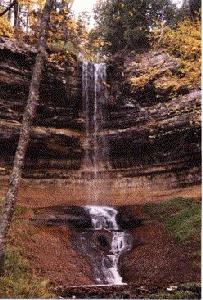
- Water Source
- Munising Creek
- Location
- Alger county, Pictured Rocks National Lakeshore, Munising
- Size
- 70 foot drop
- Directions
- From M-28 in Munising where it turns south, take H-58
east (Munising Avenue) for about 1 1/4 mile to Washington
Street. Turn north (left) onto Washington Street for just
over 1/2 mile to where the road bears right at the
hospital. The falls parking area is across the street
from the hospital. (You may follow the hospital signs to
the parking area.)
- Trail
- An easy five minute walk on a paved path from the
Pictured Rocks National Lakeshore Visitors Center takes
you to the viewing platform.
- Other Information
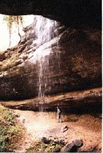
- I visited Munising Falls most recently on June 13, 1996.
I had visited it over 20 years ago. At that time we were
able to walk behind the falls because of a ledge over
which the falls drop. Both the Michigan Waterfall
book, 1988, and the Michigan Atlas & Gazetteer,
1991, indicate that you can walk behind the falls.
However, when we were there in June, 1996, it appeared
that the trail was blocked. There were wooden steps and
walkways part of the way to the falls, but they ended
before reaching the falls themselves.
-
- Munising Falls is considered one of the seven
"Notable Falls" in Michigan listed in the Michigan
Atlas & Gazetteer by Delorme Mapping.
Return to Waterfalls in Alger
County I
Page last updated 29 Jul 2006.
Email comments to dmmaki@MichelesWorld.net

